Silsden School Planning App 17/05793/REG
This planning application will affect everyone in Silsden, whether you have primary age school children or not. The position of the proposed new school is such it will generate a lot of extra traffic and has the potential of making Silsden impossible to get through at peak periods of the day. It will also open up the Banklands land for the building of many more houses with access via a road from above Tannery Corner (Bolton Road) – This will not be a bypass. With this in mind, I urge you to read the documents below and make your comments to Bradford.
17/05793/REG | A fit for purpose 3.FE primary school and nursery, which includes a future-proofed design to enable a 4.FE school provision. External works to include utility connections/diversions, landscaping, car parking, highways, external play and sports provision. | Land At Hawber Lane Silsden West Yorkshire
This planning application is now available for view, although at the time of writing the Highways Report is not available because it has not been published.
There are a lot of documents associated with this project – the following can be viewed from this website (rather than from the Bradford Planning Portal). These are the major documents published so far which will allow you to see the proposal without having to view duplicates and view “every” document.
All the documents are in pdf format, many are large and are best viewed on a desktop computer, or using a laptop.
Read this first.
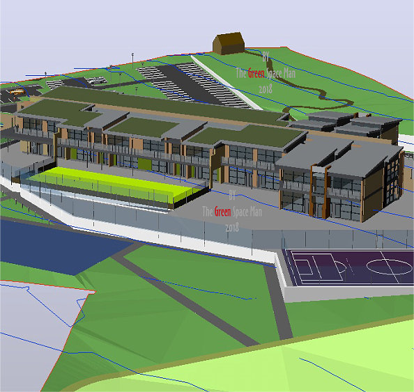
DESIGN___ACCESS_STATEMENT-4977966 This is a large document ( 2522Kb) but it should be your starting point. It provides an overview of the project. Did You Know, there will be 100 car parking spaces for staff and 15 visitor spaces, 640 pupils + nursery places. There will be a one-way system with traffic entering via Bolton Road – Dale View – Banklands Lane – Hawber Cote Lane (into the school) – round the back of the school with lots of drop off spaces and exit via Middleway – Daisy Hill – Howden Road – Kirkgate …. NICE!
… and there is no Highways Report for a proposed traffic management.
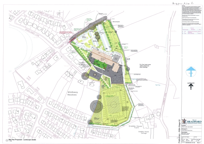
RIBA_STAGE_02_-_SITE_PLAN_PROPOSED_LANDSCAPING-4993013 (2425Kb) This is worth downloading, it is a fairly comprehensive plan of the layout and there are notes which are worth expanding to read. Why 4-11 year olds need a full-size football pitch I have no idea, but it looks like it will be expensive to make and maintain and there are no swimming facilities. A 2.4m fence will surround the school site. The footpath which goes from the top of Banklands Lane towards the east will be closed and cease to exist because it bisects the school site.
TRANSPORT_ASSESSMENT_V1.0-4993012 (18552Kb) Apparently, Bradford has carried out a traffic survey and “although the site is difficult to access everything will be alright!” The survey appears to be data from other traffic surveys combined to make an “alright” case. The baseline of 2017 being everything is OK and in 2023 there might have to be something done to manage the traffic, this seems to be 6 years too late when something should be done now. It estimates 47% of students, at the current site, arrive by car and this figure will increase to 66% for the new school. There doesn’t appear to be any correlation in the traffic survey to the extra traffic and congestion which will be generated through Kirkgate by the new school. Many of the pictures at the end of the document are taken from Google Street Map which makes you wonder if they ever actually visited the site. This document seems to be a work of fiction.
What’s the building actually going to look like?
Decide for yourself, this is typical off the shelf school building, but why it has to look like Noddy Town and be clad in many different colours rather than traditional stone I have no idea.
BUILDING_ELEVATIONS-4977814 (1398KB)
BUILDING_EXTERNAL_PERSPECTIVES-4977772 (1597Kb)
BUILDING_PLANOMETRICS_AND_INTERNAL_PERSPECTIVES-4977771 (3491Kb)
GROUND_FLOOR_PLAN_PROPOSED-4977769 (153Kb)
FIRST_FLOOR_PLAN_PROPOSED-4977768 (109Kb)
Will the students have to wear wellies?
FLOOD_RISK_ASSESSMENT-4993015 (6096KB) According to this document they won’t have to wear wellies. This is a Flood Zone 1 site and not at risk of flooding from other sources. This conclusion seems a little naive when the land to the east has a high runoff area during the winter months. Where the proposed football pitch is – on old maps, the word Spring can be found! Spring Bank is a bit of a clue in case you missed it!
REVISED_DRAINAGE_STRATEGY-4993014 (5666Kb) Amongst other measures to alleviate runoff from the site, 2 ponds are proposed. I’m not sure how this feature sits with safety for a school? One of them is near the nursery building. There is a proposal, rather than open ponds, to store the excess runoff water under the football pitch. The strategy is only concerned with the runoff from the site itself and there doesn’t appear to be any plans to control runoff onto the site from the higher ground to the east, which at present, is absorbed by the ground which will become a concrete surface when the school is built. There could be a groundwater problem once the school is built.
GEOTECHNICAL_REPORT-4977975 (1646Kb) This document details the state of the ground beneath the school building. Note: boreholes were only taken where the new school building will sit.
What will happen to the trees which have Tree Protection Orders – (TPOs)?
APPENDIX_4_TREE_CONSTRAINTS_PLAN_PDF-4977781 (472Kb) Map of the tree locations.
APPENDIX_1_TREE_DATA-4977780 (57Kb) A report on the condition of trees on the site and recommendations.
Trees – unsafe or in the way (3556Kb) This is not a planning document. It shows the trees which will be removed – those that are unsafe and those that are in the way, overlaid onto the plans for the school.
PRELIMINARY_ECOLOGICAL_APPRAISAL-4977777 (2384Kb) Where the bats might live and other such things.
I hope the above is of some use and goes some way to helping you understand how this new school will affect the community. The opinions expressed above are my own.
If you would like to let Bradford know what YOU think of the plans you should make your comments on the Bradford Planning Portal (where the full set of documents are available). You can also write to them.
How to submit your comments forTHE PLANNING APPLICATION AND DOCUMENTS: Re 17/05793/REG | A fit for purpose 3.FE primary school and nursery, which includes a future-proofed design to enable a 4.FE school provision. External works to include utility connections / diversions, landscaping, car parking, highways, external play and sports provision. | Land At Hawber Lane Silsden West Yorkshire
Use this link
planning.bradford.gov.uk/online-applications/
…. and on the page search for planning application number
17/05793/REG
Related articles on this website
 August 12, 2013 Town Hall refurb uncovers hidden treasures
 November 3, 2013 Silsden Bonfire Night 2013
 November 30, 2014 Silsden’s Christmas Market & Lights 2014
 January 28, 2016 Mixed response for council’s “vastly improved” offer to save Silsden library from closure
 December 11, 2017 1,000 new houses could be built on land surrounding Silsden Primary School campus
 March 20, 2014 Silsden – Life Box is installed ready for first defibrillator


Leave a Reply
Want to join the discussion?Feel free to contribute!